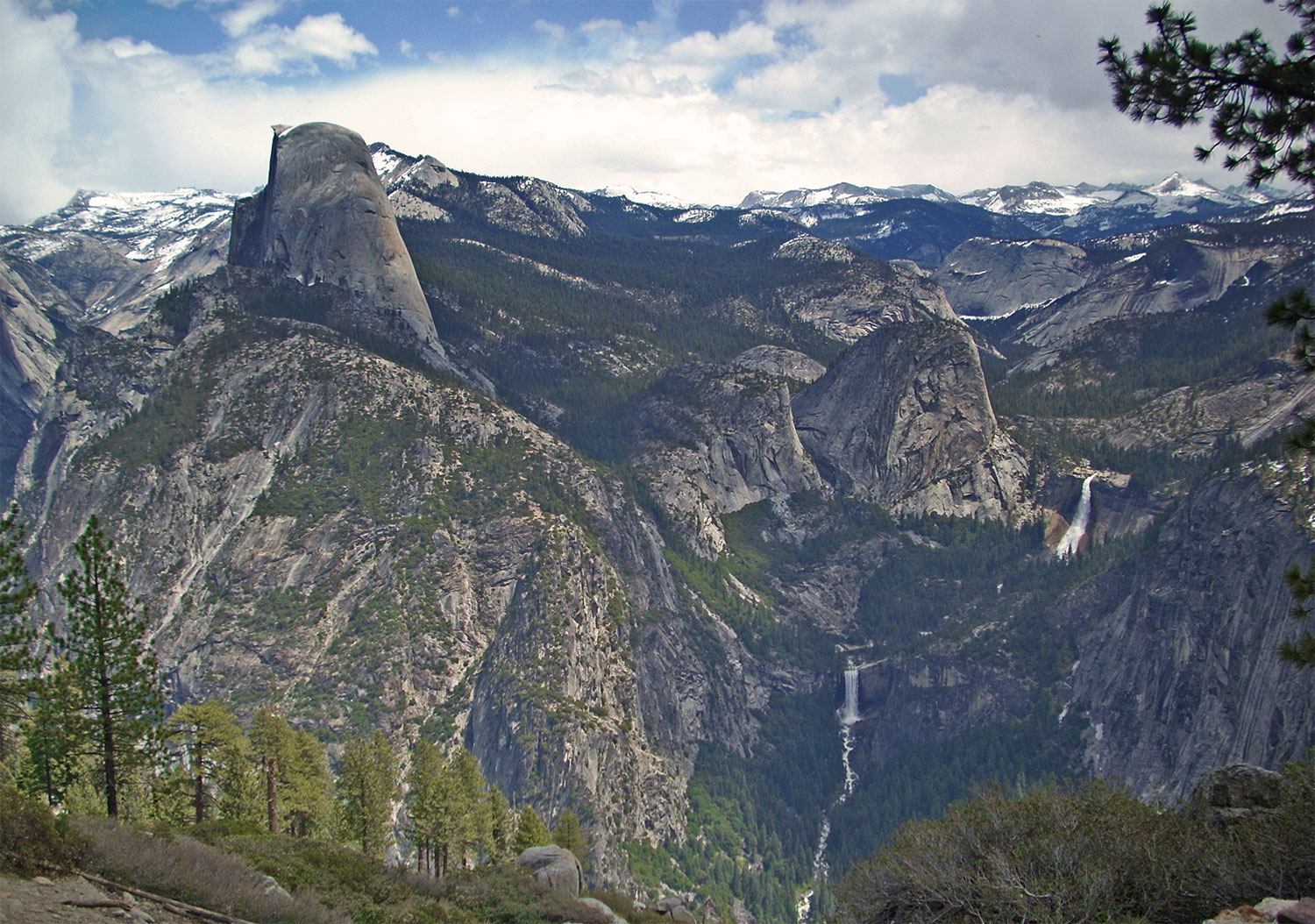
That is a hard question to answer, and yet it is a no-brainer. John Muir was asked a similar question of a man who only had one day to see the Yosemite Valley, his answer was to sit down and cry. My answer is to find your happy place. In this case Happy Isles trail head to Vernal Falls trail and Nevada Falls Trail. If you can only take one hike in the valley this is it. Why?, because you will not find a more austere, challenging and beautiful hike in the valley. You will find yourself hiking along a verdant river valley filled with a wild and lush variety of plants, flowers, trees, animals, cascades, granite cliffs, song birds, mists, and rainbows. Did I mention water falls?. Then there are two of the most lovely and awesome water falls to be found anywhere in the world that run all year round. Interested?, read on.
This very popular hike originates near Happy Isles in eastern Yosemite Valley (shuttle stop #16). This first paved mile of trail is busiest and accesses the Vernal Fall Footbridge. This section of trail gets steep quickly, and during the spring runoff, when the water is high, fast, and the sound of its many cascades rise booming off of the surrounding cliffs you can see Illillouette Falls tumbling into the valley below.
Bikes, pets and strollers are prohibited on this trail. If I had a dollar for every person I've seen with pets and strollers I could retire in comfort, go figure. I am just thankful that no one I have seen is crazy, disrespectful or silly enough to try and ride a bike on this steep often crowded trail.
Once to the top you will find an excellent view of Vernal Fall from the footbridge at 0.8 miles (1.3 km). Don't forget to turn around here and look in the other direction downstream for some wonderful views as well. In winter be careful on the final little hill going down toward the foot bridge it an be icy and oh so slippery.
There is a rest room and a water station located a short distance beyond the foot bridge. They are both closed in the winter when the snow starts, and opens in the spring. Due to high water the water station may have a delayed opening. In the summer this is the last water station. From here on out you will need to carry your own water, or have a water filter to safely drink from the river or lakes.
About 0.2 miles (0.3 km) beyond the bridge, the Mist Trail and the John Muir Trail diverge. To proceed directly to the top of Vernal Fall, follow the Mist Trail 0.5 miles (0.8 km) up a steep granite stairway of over 600 steps.
Prepare for slippery footing and a tremendous amount of waterfall spray in spring and early summer. Along the trail you will see views of Vernal Falls. It is very common to see a rainbow in the spray coming from the base of the falls. Depending on the sun and time of day you may see double rain bows, or even 360 circular rain bows. Though you may have to get soaking wet to view them. If you look closely enough and the sun is right you will see rainbows coming from the mists in the rapids of the river.
At the top of Vernal Fall, you can take in views looking straight down the length of the 317-foot waterfall, use caution the ground and rocks are extremely slippery in this area.
Continuing along the Mist Trail, you’ll experience another 1.5 miles (2.4 km) of steep, rocky switchbacks in order to reach Nevada Fall. Crashing down 594 feet, this thunderous waterfall is fullest in spring and early summer, and you will find terrific photographic opportunities along this stretch of trail.
At the top of the climb, head right to reach the footbridge that crosses the Merced River above the fall, allowing you a closer view of it. Use extreme caution while you're near any flowing water or wet rock in this area.
There is also a pit toilet located at the top, that is the last toilet until you reach Little Yosemite Valley.
From here, you can either return down the Mist Trail, or continue over the bridge to the John Muir Trail for an alternate route back to Yosemite Valley. If you choose the John Muir Trail, you will enjoy different scenery, with great views of Liberty Cap and different views of Nevada Fall. The John Muir Trail is longer—approximately 4 miles one-way compared to the Mist Trail 2.5 miles (4 km)—so plan accordingly.
Some hikers may be continuing from the top of Nevada Fall to hike to Half Dome or elsewhere in Yosemite’s wilderness. A popular place for backpackers is Little Yosemite Valley. There is a ranger station, and pit toilets there. You will need a back country permit to camp there. Many hikers use Little Yosemite Valley as a base camp and then tackle Half Dome the next day.
Beware, it is country bear jamboree there. Watch your food and use the bear boxes. Many startled campers have woken up to a bear head in there tent looking for that tasty candy bar they went to bed with. Don't worry they are not looking for tasty campers, that would be Yellowstone.
Vernal Fall Footbridge Trail
DISTANCE: 1.6 mi (2.6 km) round trip
ELEVATION GAIN: 400 ft (120 m)
TIME: 1-1.5 hours
Top of Vernal Fall
DISTANCE: 2.4 mi (3.9 km) round trip (via Mist Trail)
ELEVATION GAIN: 1000 ft (300 m)
TIME: 3 hours
Top of Nevada Fall
DISTANCE: 5.4 mi (8.7 km) round trip (via Mist Trail)
ELEVATION GAIN: 2000 ft (610 m)
TIME: 5-6 hours
You can hike to both waterfalls all year. However, in winter, there is a specific route that remains open while some sections of trail are closed. The lower portion of the Mist Trail along Vernal Fall closes in winter due to risk of falling ice and rock.
The upper portion of the John Muir Trail between Clark Point and the top of Nevada Fall is closed in winter due to treacherously icy conditions.
Keep in mind that the sections of trail that remain open in the winter may be very icy and/or snowy.
Be aware of slick conditions along the south side of this loop trail during winter and early spring. With few natural barriers to hold onto or to brace yourself, it is fairly easy to slip and fall. This section of trail often remains covered in snow and ice, even when the north side of the loop is snow-free. When winter conditions exist, consider making an out and back trip along the north side of the loop.
Drinking water is not available at the trail head or along the trail. Come prepared, and if you opt to extend your hike to travel the full Mirror Lake Loop or up the Snow Creek Trail, plan accordingly.
Drinking water is available at the shuttle stop near the trail head (stop #16) and also at the Vernal Fall Footbridge (May to October). This is the only drinking water available along the trail, so carry plenty of water for your hike.
Unlike many other trails in the park, several restrooms are available along your hike. Restrooms are located at the shuttle stop near the trail head (stop #16). Additionally, restrooms are located at the Vernal Fall footbridge, approximately 1 mile up the trail (May to October). Vault toilets are available beyond the top of Vernal Fall (along the Mist Trail) and at the top of Nevada Fall (along the Mist Trail).
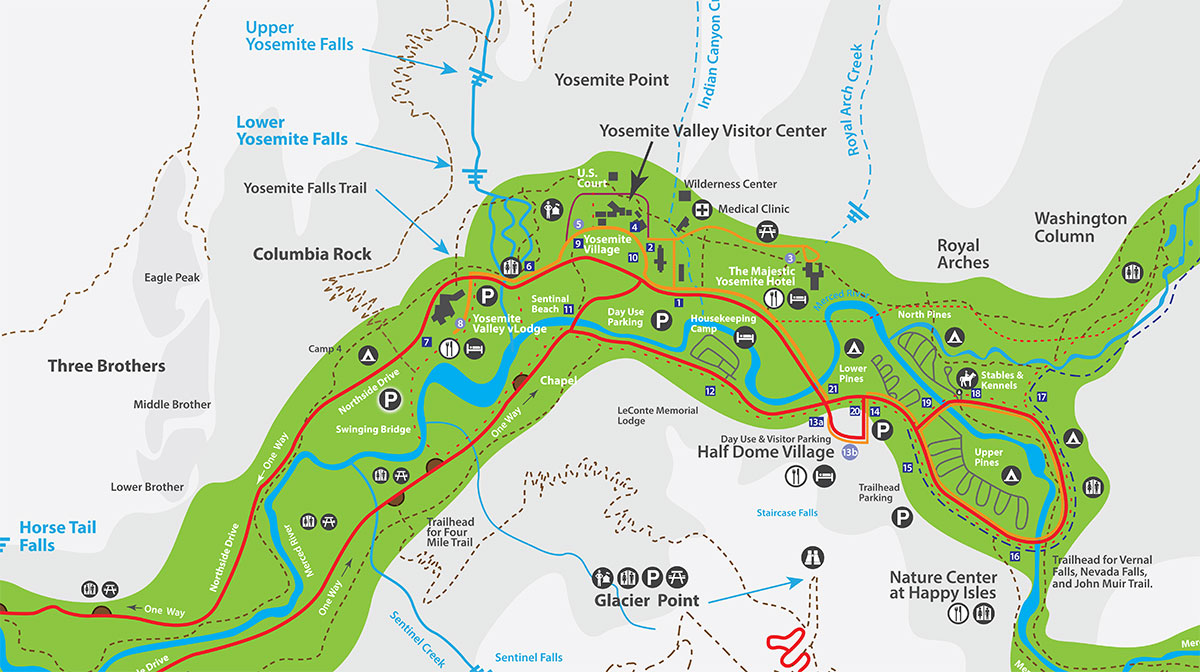
Parking is not available at the trail head itself. The nearest parking is at the trailhead parking lot (see map) , roughly half a mile from the trailhead. If the trailhead parking lot is full, you can park at Half Dome Village (formerly Curry Village), less than one mile (1.6 km) from the trail head. However, accessing the trail head is easy by taking the Valley Visitor Shuttle (7 am to 10 pm year-round) to shuttle stop #16.
Ride the Valley Visitor Shuttle (7 am to 10 pm year-round) to shuttle stop #16 and follow the signs across the bridge to where the trail begins. There is also a bike rack near the bridge at Happy Isles.
Pets, bicycles, and *strollers are prohibited.
Do not shortcut switchbacks, which causes rapid trail erosion and results in injuries.
When in large groups walk single file on crowded days.
Keep your food within arm's reach at all times and do not feed the wildlife
Carry out all trash and food waste (fruit peels, shells, etc.).
* Strollers: I see folks go as far as Vernal Falls with strollers. They are actually prohibited but there you are. The Rangers seem too busy to say or do much about it. You will need to decide what you will do based upon your own set of values, and not because there is a guard posted to keep strollers, dog, and bicycles out. Just keep in mind that the trail is paved but very, very steep and very crowded with people of all ages, includeing back packers accessing the back country from Happy Isle. It is a trail but in the summer I would call it a freeway.

Proprietor: Vonnie Coombs
Cell: 619-948-8561
7509 Henness Circle, Yosemite CA, 95389
E-mail: reservations@yosemiteperegrinelodge.com
 Yosemite Peregrine Lodging is located inside the gates of Yosemite National Park in the Yosemite West development. You have to enter Yosemite to get to Yosemite West. Don't let other hotel operators fool you. Ask for a physical address and check them out on a map before you make your reservation. Some accommodations claim to be minutes from Yosemite and are actually an hour or more.